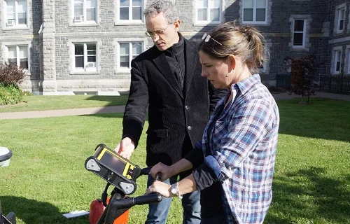
Dr. Jonathan Fowler (l); Greg Baker (behind), Instrument Technician with the Maritime Provinces Spatial Analysis Research Centre, part of the Saint Mary's Geography department; Sara Beanlands (senior archaeologist at Boreas Heritage Consulting and an adjunct professor in the Anthropology department).
This past semester, the Department of Anthropology at Saint Mary’s added a new device to its archaeological arsenal: the Noggin 500, a ground-penetrating radar (GPR) that will help students and faculty literally see beneath the soil as they explore some of Nova Scotia’s most important historic sites. The instrument is designed and built by Sensors & Software of Mississauga, Ontario.
“GPRs are used commonly in research and archaeological consulting internationally,” says Anthropology Professor Dr. Jonathan Fowler, “but less often in our region. We hope to change that.”
The purchase was a joint partnership between Boreas Heritage Consulting and Northeast Archaeological Research, two Halifax-based archaeological consulting companies. Sara Beanlands is an archaeologist with Boreas, a graduate of Saint Mary’s History program, and an adjunct professor in the Anthropology Department. She says it’s critical for students to have access to this kind of technology: “It’s already a standard part of archaeological practice in many parts of the world, and will become so here as well.”
Saint Mary’s students already have access to the Geonics EM38B, a device which measures soil magnetism and can put together a limited picture of what lies underneath. It’s especially good at seeing places where buildings have been burned and no visible traces remain—after burning, the soil’s magnetism is enhanced. This is especially helpful at sites such as the burned Acadian village at Grand-Pré.
The addition of the Noggin—with a different set of strengths—complements the EM38’s abilities and puts a whole other underground world within reach. Whereas the EM38 sees best in the top 50 centimetres of soil, the Noggin can see as much as two metres down, and can map the subterranean environment in three dimensions. The Noggin GPR is especially good at spotting “discontinuities” in soil texture and type, such as those caused by unmarked graves.
The result of this expanding technological toolkit is a more accurate sense of what lies where, especially valuable when making the most of time in the field.
“It’s important for students to learn the traditional approaches to mapping and examining sites,” says Beanlands, “but these absolutely help us focus where to dig and figure out where there’s better potential to find a site of interest.”
So far, Dr. Fowler has run a series of test surveys at archaeological sites in Nova Scotia. In collaboration with Parks Canada, the GPR is also being used at national historic sites, including Grand-Pré in the Annapolis Valley and Citadel Hill in Halifax. To call the early results promising would be an understatement.
“We’re seeing archaeological features we’ve never seen before,” says Dr. Fowler, “and it’s honestly totally changing my interpretation of certain things. The complementary principle is really playing out…and it’s giving students access to skills and training that are very rare, maybe unique, in Canada right now. This will be extremely important to their future careers.”


